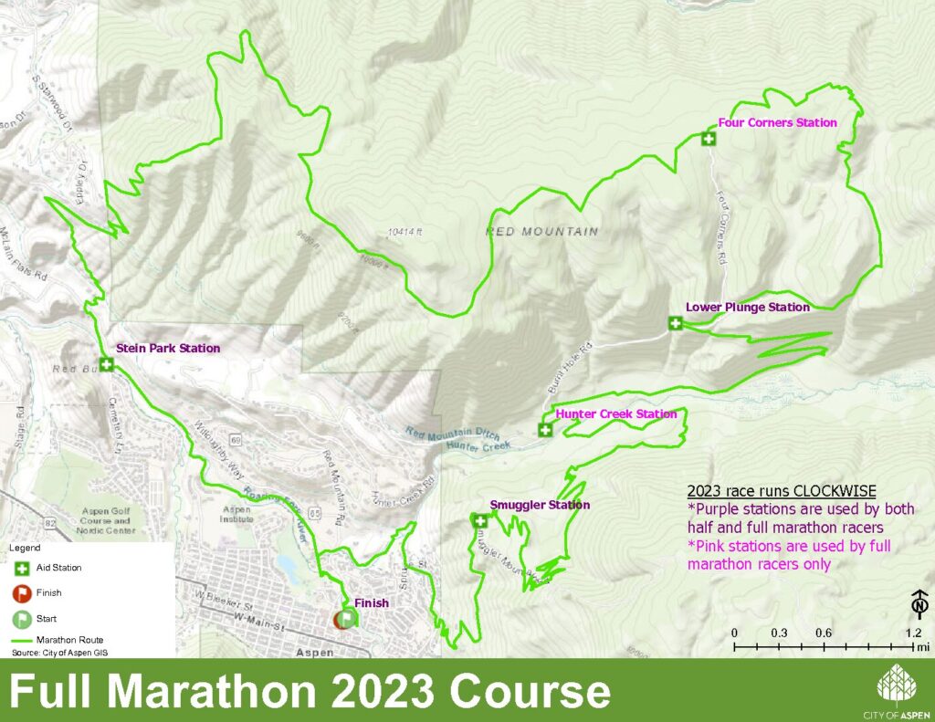
Marathon Course 2023 ‘Clockwise’
The Marathon will start at Rio Grande Park at 6:30am (Cut off times at aid stations will be enforced) Course limit 8 hours
Start – 6:30am The marathon will start at Rio Grande Park.
Close to 3100ft of elevation Gain.
2023 Aspen Backcountry Marathon Course Description
Take the Dirt Trail through the John Denver Sanctuary across the Krajian Bridge.
Turn left onto the Grindlay Bridge and cross the Roaring Fork River and then a right turn onto the Music Tent single track trail.
Cross the Roaring Fork River again via the Picnic Point Bridge and turn left on the Rio Grande
Trail.
Follow the Rio Grande Trail and adjacent single-track trails to Stein Park and Aid Station #1 at 2.7 miles until a right turn onto the Sunnyside Trail.
Follow the Sunnyside Trail until it joins the Shadyside Trail (USFS #1988.1). Turn left onto the Shadyside Trail and follow it until the Shadyside Cutoff (USFS #1988.2).
Turn left onto the Sunnyside Trail (USFS #1987.1).
Turn Right onto the Secret/Jedi Trail (USFS#1987.3) and follow it past the Upper Plunge Trail to the Red Mountain Communications Site Road.
Follow the road to 4 corners to Aid Station #2 at 11 miles.
Take the Hobbit Trail (USFS 1989.3) out of 4 corners. And take a right onto Burnt Hole Road (USFS #22).
Take a left on the Hunter Creek Toll Road (USFS #20A).
Turn Right on the Hunter Creek Overlook Trail (USFS #2491.1) and bear left onto the Hunter Creek Toll Road again and follow it until you reach the Hummingbird Trail and Aid station #3 at 14.7 miles.
Take the Hummingbird Trail to the Hunter Creek Valley North Trail. (USFS#21A.1).
Bear right and follow the Hunter Creek Valley North Trail follow it to the Hunter Creek Toll Road.
Turn left on the Hunter Creek Toll Road for ¼ mile to Aid Station #4 at 17.51 miles.
Turn left on Hunter Creek Shortcut Trail back up to the North Spur Trail. Cross the 10th Mountain Bridge and turn right on the Hunter Creek Trail.
Follow the Hunter Creek Valley Trail and Turn left onto the Hunter Creek Cutoff Trail.
Follow the Hunter Creek Cutoff Trail and turn left onto the Hunter Creek Valley South Trail (USFS#21A.1).
Take the Hunter Creek Valley South Trail up to the Iowa Shaft Trail (USFS#2172.1).
Follow the Iowa Shaft Trail to up to the new Lower Lollipop Trail. Take the new lower Lollipop trail to the Lollipop trail.
Follow the Lollipop Trail to the Tootsie Roll Trail and onto the BTS Trail.
Head down the BTS Trail onto Smuggler Mountain Road to Aid Station #5 at 23.4 miles.
Head Down Smuggler Mountain Road.
Turn Right onto Silverlode Drive, take Williams Ranch Road to the Lani White Trail. Take a left on the Hunter Creek Trail to the Rio Grande Trail.
Take a left on the Rio Grande Trail and follow it back to the finish at Rio Grande Park.
Marathon Aid station locations. Cut off times are TBD*
| Mile | Location | Supplies | Cut-off Times |
| Stein Park | Water, Skratch, snacks | ||
| 4 Corners | Water, Skratch, snacks | ||
| Top of Lower Plunge | Water, Skratch, snacks | ||
| Hunter Creek Senior Lot | Water, Skratch, snacks | ||
| Smuggler Mountain Rd. | Water, Skratch, snacks | ||
| Finish Line | Water, Skratch, snacks |


